
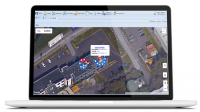
This integration allows users of PEMAC Assets to initially view an overhead image of their building(s) – as it would appear in Google Maps overhead street view.
Overlaid on this image will be several pins – identifying the locations where current Work Orders & Visit Requests exist. Detail on each pin can then be displayed with further information on the requirements. This helicopter view gives a visual image of requirements by location.
Clicking further on the building will then zoom the user to a closer image, with sublocations highlighted, such as floors or different areas in the building. And again, a further click will zoom right to actual images of assets in that sublocation – with full asset history and current activity displayed.
This Google Maps update gives an ideal visualisation of work required matched to locations, and finally to assets – specifically useful for larger plants or those with many Assets.
Further details can be found here!
t: 0161 509 2492
e: sales@pemac.com
w: pemac.com
